Category:Drought in the United States
Jump to navigation
Jump to search
| Upload media | |||||
| Location |
| ||||
|---|---|---|---|---|---|
| |||||
Subcategories
This category has the following 12 subcategories, out of 12 total.
- Drought in Arizona (5 F)
- Drought in Nevada (9 F)
2
- 2011 Southern US drought (25 F)
- 2016 New York drought (8 F)
D
Media in category "Drought in the United States"
The following 120 files are in this category, out of 120 total.
-
 20111216-NRCS-LSC-0042 - Flickr - USDAgov.jpg 4,144 × 2,427; 2.2 MB
-
 20111216-NRCS-LSC-0047 - Flickr - USDAgov.jpg 3,961 × 2,626; 1.47 MB
-
 20111216-NRCS-LSC-0064 - Flickr - USDAgov.jpg 3,832 × 2,680; 1.36 MB
-
 20111216-NRCS-LSC-0074 - Flickr - USDAgov.jpg 4,288 × 2,848; 3.66 MB
-
 20111216-NRCS-LSC-0096 - Flickr - USDAgov.jpg 3,863 × 2,645; 2.56 MB
-
 20111216-NRCS-LSC-0120 - Flickr - USDAgov.jpg 3,808 × 1,964; 1.26 MB
-
 20111216-NRCS-LSC-0151 - Flickr - USDAgov.jpg 4,819 × 1,937; 1.63 MB
-
 2014-009 - dry folsom - Flickr - Robert Couse-Baker.jpg 4,416 × 2,484; 3.87 MB
-
 2016 Connecticut Drought Map.png 1,056 × 816; 25 KB
-
 20210717-APHIS-LSC-0404 (51341776925).jpg 4,000 × 3,000; 7.45 MB
-
 Aerial views of drought affected Colorado (9306).jpg 4,928 × 3,264; 2.46 MB
-
 Aerial views of drought affected Colorado (9308).jpg 4,928 × 3,264; 1.93 MB
-
 Aerial views of drought affected Colorado (9309).jpg 4,928 × 3,264; 1.35 MB
-
 Alapaha River.jpg 400 × 300; 45 KB
-
 Antelope Point Public Launch, August 2021 (5427920c-4964-4f8e-8f46-999f30609c43).JPG 5,184 × 3,456; 8.03 MB
-
 Antelope Point Public Launch, August 2021 (8b25e398-52d9-4ac6-bff9-64a050057170).JPG 5,184 × 3,456; 8.06 MB
-
 Antelope Point Public Launch, August 2021 (b2cbf42b-2dc5-4ead-9d11-76284ba58324).JPG 5,184 × 3,456; 8.46 MB
-

-
 August 16, 2016 New York drought US Drought Monitor.png 816 × 816; 17 KB
-

-
 Barren Spillway at Garrison Dam.jpg 1,600 × 1,200; 731 KB
-
 Barren wheatfield, Malta, Montana, July 2021.jpg 4,000 × 3,000; 8.78 MB
-
-
 Big Salt Marsh,Quivira Refuge, Aug 2011 (8427237060).jpg 4,000 × 3,000; 2.29 MB
-

-
 California drought status (March 2014-2017) (33564436186).png 576 × 287; 71 KB
-
 Castle Rock Cut, August 2021 (0cd676af-a44a-4aad-9c5f-21870b4990c9).JPG 5,184 × 3,456; 6.62 MB
-
 Castle Rock Cut, August 2021 (8284b29d-f07d-4fa9-b856-0c8ccee457da).JPG 5,184 × 3,456; 5.8 MB
-
 Castle Rock Cut, August 2021 (e07aa5cd-ac5d-4264-8c0a-42925cb8fc28).JPG 5,184 × 3,456; 6.44 MB
-
 Castle Rock Cut, August 2021 (e27dc462-693a-4833-9dcd-389a37854b0a).JPG 5,184 × 3,456; 6.22 MB
-
 Castle Rock Cut, August 2021 (ed2f1720-4025-4660-ae39-c6fc0b18efe4).JPG 5,184 × 3,456; 6.83 MB
-

-
 Corn field affected by dought (12308593123).jpg 4,288 × 2,848; 9.43 MB
-
 Corn in drought, Western Kentucky, August, 2012 (cropped).jpg 2,717 × 2,117; 1.57 MB
-
 Corn in drought, Western Kentucky, August, 2012.jpg 3,240 × 4,320; 3.05 MB
-
 Corn shows the affect of drought (cropped).jpg 267 × 297; 51 KB
-
 Corn shows the affect of drought.jpg 500 × 332; 105 KB
-
 Corn-In-Drought.jpg 720 × 540; 485 KB
-
 Cornfield in 2007 drought, eastern West Tennessee (cropped).jpg 1,417 × 1,143; 2.01 MB
-
 Cornfield in 2007 drought, eastern West Tennessee.jpg 2,301 × 1,143; 2.81 MB
-
 Cornfield in drought, Idaville, Indiana, 2012.jpg 2,178 × 2,802; 4.89 MB
-
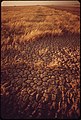 Cracked-earth--a-result-of-irrigation-and-intense-dry-heat-may-1972 7152566781 o.jpg 2,021 × 3,000; 720 KB
-

-

-

-

-

-
-

-

-
 Drought area in the United States.svg 659 × 419; 149 KB
-
 Drought conditions have hurt the playa lakes area in Anson, Texas. (24483677363).jpg 4,246 × 2,826; 4.62 MB
-
 Drought conditions have hurt the playa lakes area in Anson, Texas. (24483679763).jpg 2,832 × 4,256; 4.49 MB
-
 Drought conditions have hurt the playa lakes area in Anson, Texas. (24483691813).jpg 4,229 × 2,814; 3.62 MB
-
 Drought conditions have hurt the playa lakes area in Anson, Texas. (24742871959).jpg 4,256 × 2,832; 4.72 MB
-
 Drought conditions have hurt the playa lakes area in Anson, Texas. (24742881659).jpg 4,256 × 2,832; 4.75 MB
-
 Drought conditions have hurt the playa lakes area in Anson, Texas. (24992372152).jpg 4,256 × 2,832; 5.16 MB
-
 Drought fish kill, Chickasaw Refuge (8427237252).jpg 3,456 × 2,592; 1.16 MB
-

-
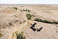
 Drought on a Montana cattle ranch, May 2022.jpg 4,928 × 3,285; 1.67 MB
-
 Drought Severity Index, OWID.svg 850 × 600; 17 KB
-
 Drought-before-after.jpg 850 × 483; 95 KB
-
 Drought-stressed corn, western Tennessee-Kentucky border.jpg 4,320 × 3,240; 3.12 MB
-
 Dry creek bed, Quivira Refuge (8426146245).jpg 3,648 × 2,736; 2.38 MB
-
 Dust devil.jpg 2,448 × 3,264; 4.8 MB
-
 DUST STORM - NARA - 544330.jpg 3,000 × 2,023; 1.28 MB
-
 DUST STORM AFTER 153-DAY DROUGHT - NARA - 544005.jpg 3,000 × 2,030; 876 KB
-

-
 Effects of the drought on Lake Mead, USA (Copernicus).jpg 4,000 × 2,540; 7.56 MB
-

-
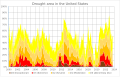
 Graph of drought levels of the contiguous united states.png 1,107 × 812; 168 KB
-
 In a shady spot.jpg 1,024 × 758; 133 KB
-
 Iowa County Drought July 2012.jpg 3,008 × 1,685; 4.46 MB
-
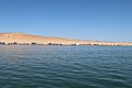
 ISS059-E-035758 (Amistad Reservoir) lrg.jpg 5,568 × 3,712; 8.1 MB
-
 July 26, 2016 New York drought US Drought Monitor.png 816 × 816; 16 KB
-

-

-
 Lake Palestine boat launch August 2011.jpg 1,600 × 1,200; 827 KB
-
 Lake Palestine drought image Summer 2011.jpg 1,600 × 1,200; 395 KB
-
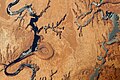 Lake Powell and The Rincon, Utah - NASA Earth Observatory.jpg 1,440 × 960; 1.53 MB
-
 Lake Powell surface area shrinkage.svg 512 × 543; 213 KB
-
 Livestock40.tif (27098035899).jpg 2,250 × 1,500; 4.56 MB
-
 Lone Rock Beach, August 2021 (8984e5d0-c31f-491c-b6c0-c363abe1e296).JPG 5,184 × 3,456; 5.58 MB
-
 Low water levels at the Hoover Dam (9299).jpg 4,234 × 2,265; 2 MB
-
 Low water levels in Glen Canyon Dam (9300).jpg 3,936 × 2,624; 6.36 MB
-

-
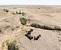 Montana drought, aerial view, cattle ranch in Fallon County, MT. June 2021 (cropped).jpg 4,447 × 3,634; 19.7 MB
-
 Montana drought, aerial view, cattle ranch in Fallon County, MT. June 2021.jpg 5,464 × 3,640; 20.4 MB
-
 Mussel stranding, Marais de Cygnes Refuge (8427237114).jpg 3,648 × 2,736; 2.31 MB
-
 Mussel stranding2, Marais de Cygnes Refuge (8426146495).jpg 2,736 × 3,648; 2.55 MB
-
 New York drought monitor April 4, 2017.png 816 × 816; 16 KB
-
 News conference on statewide drought (30533626291).jpg 1,632 × 1,224; 848 KB
-
 NOAA Winter Outlook 2022-23 Drought.png 2,100 × 1,380; 755 KB
-
 NorthPlatteRiverMay2002.jpg 1,760 × 1,100; 215 KB
-
 October 18, 2016 New York drought US Drought Monitor.png 816 × 816; 17 KB
-
 October 4, 2016 New York drought US Drought Monitor.png 816 × 816; 18 KB
-

-
-
 Path at Boat Rentals in Wahweap Bay, August 2021 (f8366146-58de-48de-8c6d-531f52af3e31).JPG 5,184 × 3,456; 7.86 MB
-

-
Projected U.S. Precipitation Changes by 2100.webm 1 min 1 s, 1,280 × 720; 6.58 MB
-
Projected U.S. Temperature Changes by 2100.webm 1 min 1 s, 1,280 × 720; 6.34 MB
-
 September 27, 2016 new york drought monitor.png 816 × 816; 18 KB
-
 September 6, 2016 New York drought US Drought Monitor.png 816 × 816; 18 KB
-
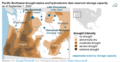
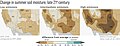 Soil moisture changes in the U.S. southwest in the late 21th century.jpg 1,400 × 542; 339 KB
-
 Stateline Launch Ramp, August 2021 (efa7dd30-4d71-47e8-bb71-6d275461dfab).JPG 5,184 × 3,456; 6.99 MB
-

-

-
The Truth Behind the Manmade Water Crisis in the West.webm 2 min 28 s, 1,920 × 1,080; 13.01 MB
-
Tracking Deluge and Drought through Soil Moisture- Part 2.webm 1 min 45 s, 3,840 × 2,160; 143.47 MB
-
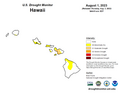 U.S. Drought Monitor for Hawaii 2023-08-01.png 1,056 × 816; 32 KB
-
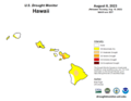 U.S. Drought Monitor for Hawaii 2023-08-08.png 1,056 × 816; 15 KB
-
-
 Usdroughtjune30.gif 646 × 530; 22 KB
-
 Utah drought conditions (March 31, 2020).png 1,056 × 816; 55 KB
-

-
 Wahweap Boat Launch, August 2021 (3f719ff9-04f6-41b5-bb09-066fe64988a6).JPG 5,184 × 3,456; 7.02 MB
-
 Wahweap Launch Ramp, August 2021 (68f0e020-5151-4aa3-a21c-5dc73a4fb343).JPG 5,184 × 3,456; 6.95 MB
-
 Water flowing 4 (6466592407).jpg 2,784 × 1,856; 2.61 MB
-
 Zin200512 pg.gif 650 × 534; 71 KB


.jpg)
.jpg)
.jpg)
.jpg)

.JPG)
.JPG)
.JPG)


.jpg)
.JPG)
_(33564436186).png)
.JPG)
.JPG)
.JPG)
.JPG)
.JPG)

.jpg)
.jpg)

.jpg)


.jpg)


.jpg)
.jpg)
.jpg)
.jpg)
.jpg)
.jpg)
.jpg)


.jpg)


.jpg)


_lrg.jpg)


.jpg)
.JPG)
.jpg)
.jpg)
.jpg)
.jpg)

.jpg)
.jpg)

.jpg)


.jpg)
.png)
.JPG)
.jpg)


.JPG)

.jpg)


.png)
.jpg)
.JPG)
.JPG)
.jpg)
